Determining Latitude and Longitude Using a Multi-Sensor System on a Jetson Nano
1. Introduction
The increasing demand for precise and dependable localization across a multitude of applications, including autonomous vehicles, unmanned aerial systems, and robotic platforms, has spurred significant advancements in navigation technologies. This is particularly pronounced in scenarios where reliance on conventional Global Navigation Satellite Systems (GNSS) like GPS is compromised due to signal obstruction, jamming, or spoofing. To address these limitations, the integration of diverse sensor modalities through sophisticated fusion techniques presents a promising avenue for achieving more resilient and accurate navigation solutions. The Jetson Nano, with its compact form factor and substantial processing capabilities, serves as an ideal platform for implementing complex sensor processing and fusion algorithms in embedded systems.
This report addresses the challenge of accurately determining latitude and longitude by leveraging a comprehensive suite of sensors interfaced with a Jetson Nano. The sensor configuration includes an upward-facing star-tracking camera designed for celestial navigation, a downward-facing camera and four directional cameras for visual odometry, an Inertial Measurement Unit (IMU), a magnetometer coupled with an Earth's magnetic force database, optical flow cameras, a Lidar system, ultrasonic sensors, and both RTK (Real-Time Kinematic) and Doppler GPS receivers. The primary objective is to explore the fundamental principles underpinning each of these sensing technologies and to investigate methodologies for effectively fusing their data streams to derive a robust and precise estimate of the device's latitude and longitude, even in environments where GPS signals are unreliable or unavailable. This endeavor necessitates a thorough examination of celestial navigation, visual odometry, inertial navigation, magnetic heading determination, and map-aided localization, culminating in the application of advanced sensor fusion algorithms to synergistically combine these heterogeneous data sources, which exhibit varying noise characteristics, update rates, and potential failure modes.
The subsequent sections of this report will delve into the operational principles of each sensor within the described configuration. It will investigate how each sensor can be individually utilized to contribute to the overall localization task. Furthermore, the report will detail specific techniques for fusing the data derived from these sensors to obtain a highly accurate and dependable estimate of latitude and longitude. Special attention will be paid to the role of the onboard Earth's heightmap and satellite imagery in augmenting the localization process. Finally, the report will explore various sensor fusion algorithms suitable for this application, considering their computational demands and potential for implementation on the Jetson Nano platform.
2. Determining Latitude and Longitude via Celestial Navigation
Celestial navigation, also known as astronavigation, is a time-honored practice of determining a position on the Earth's surface by observing the positions of stars and other celestial bodies.[1, 2] This method allows a navigator to ascertain their location without sole reliance on estimated positional calculations or modern electronic aids.[1] The fundamental principle involves understanding the celestial sphere, an imaginary sphere of infinite radius with the Earth at its center, upon which all celestial objects appear to be projected. Just as locations on Earth are defined by latitude and longitude, celestial objects are located using declination (analogous to latitude) and right ascension (analogous to longitude).[3, 4]
A key technique in celestial navigation involves measuring the angle between a celestial body and the visible horizon, known as the altitude. This measurement, when combined with the precise time of observation and knowledge of the celestial body's coordinates from a celestial almanac, allows the derivation of a line of position (LOP).[1, 5] The observer's true location lies somewhere along this line. Historically, accurate timekeeping was paramount, requiring a marine chronometer to establish the precise time of the sight.[1] While traditional celestial navigation relied on manual measurements using instruments like sextants and subsequent manual calculations, the inclusion of an upward-facing star-tracking camera in the described system enables a high degree of automation.[6]
The upward-facing camera, equipped with a star tracker, is capable of imaging individual stars both during the day and night.[7] This capability is crucial for providing an alternative to GPS in scenarios where satellite signals are unavailable. Automated star detection and pattern recognition algorithms are essential for identifying the observed stars.[7, 8, 9, 10, 11, 12, 13, 14, 15, 16] Daytime star tracking often employs infrared imaging techniques to mitigate the effects of atmospheric scattering of sunlight, which can obscure stars in the visible spectrum.[7, 17, 18] Several companies are actively developing daytime star trackers as a resilient alternative to satellite positioning systems.[17, 18, 19, 20, 21, 22]
Determining latitude from star observations in the Northern Hemisphere can be achieved relatively simply by measuring the altitude of Polaris, the North Star, above the northern horizon. This angle is approximately equal to the observer's latitude.[2, 3, 23, 24, 25] For locations in the Southern Hemisphere, or when Polaris is obscured, latitude can be determined by observing other stars and using their known declination and the measured altitude at the time of observation.[3, 26] Observing multiple stars and calculating their respective LOPs can enhance the accuracy of the latitude determination, as the intersection of these lines provides a more precise fix.[6]
Determining longitude through celestial navigation involves comparing the local sidereal time (LST) of a star's culmination (its highest point in the sky) with the Greenwich Sidereal Time (GST) at that exact moment.[27] The right ascension (RA) of a star that is culminating at the observer's location is equivalent to the local sidereal time.[4, 27] The difference between GST and LST directly corresponds to the observer's longitude.[4, 27] Historically, the invention of the marine chronometer by John Harrison was a pivotal moment, as it enabled navigators to maintain accurate time at the Prime Meridian, a prerequisite for precise longitude calculation.[5, 28, 29]
Several algorithms are employed for star identification in automated celestial navigation systems. These include the triangle algorithm, polygon algorithm, grid algorithm, neural network algorithm, genetic algorithm, and the one-dimensional vector pattern (one\_DVP) algorithm.[8, 9, 10, 11, 12, 13, 14, 15, 16] The one\_DVP algorithm, for instance, utilizes the spatial geometry of observed stars to form a unique, rotation-invariant feature vector, facilitating rapid and robust star identification.[8, 13, 14] When considering implementation on the Jetson Nano, the computational resources required by these algorithms and the availability of relevant software libraries (such as those used in face recognition projects on the platform [30, 31] or AI-guided telescope control [32]) are important factors.[33] The choice of star identification algorithm directly impacts the accuracy and speed of celestial navigation, particularly on an embedded system with limited computational resources.
3. Visual Odometry for Relative Positioning
Visual odometry (VO) is a technique used to estimate the motion of a device over time by analyzing sequences of images captured by onboard cameras.[34, 35] This is achieved by tracking distinctive features or directly analyzing pixel intensities across consecutive frames to determine the camera's displacement and orientation.[34, 35] Unlike absolute positioning methods like GPS or celestial navigation, VO provides relative motion estimates, meaning it tracks the changes in the device's position and orientation with respect to its starting point.
The downward-facing camera in the described configuration can be effectively used for visual odometry by analyzing the movement of features on the ground as observed in the captured images.[34, 35, 36] This approach is applicable in both indoor and outdoor environments, provided that the surface below the device exhibits sufficient texture or distinguishable features that can be tracked reliably.[34] Utilizing a single downward-facing monocular camera offers advantages in terms of cost and computational simplicity compared to stereo vision setups, which require more complex processing to extract depth information.[34, 35]
To enhance the capabilities of visual odometry, the system also includes optical flow cameras. Optical flow sensors directly measure the apparent motion of objects within their field of view, providing 2D velocity estimates.[36, 37] Fusing the data from these optical flow cameras with measurements from the IMU can significantly improve the accuracy and robustness of the overall visual odometry system, especially in challenging scenarios characterized by rapid device motion or poor lighting conditions where feature tracking might become unreliable.[36, 37] The combination of a downward-facing camera analyzing ground features and optical flow cameras providing velocity information offers a more comprehensive understanding of the device's relative motion.
When considering the implementation of visual odometry on the Jetson Nano, leveraging existing computer vision libraries such as OpenCV is crucial. OpenCV provides a wide range of functionalities for feature extraction (e.g., SIFT, ORB), feature matching, and optical flow computation (e.g., Lucas-Kanade algorithm).[30, 34, 35] Furthermore, research has been conducted on adapting and optimizing visual odometry algorithms specifically for ARM-based architectures like the one found in the Jetson Nano, demonstrating the feasibility of running these algorithms in real-time on the platform.[33]
4. Local Mapping and Pose Estimation through Multi-Sensor Fusion
The Inertial Measurement Unit (IMU) is a critical component for local mapping and pose estimation, providing high-frequency measurements of the device's linear acceleration and angular velocity across three axes.[38, 39, 40, 41] By integrating these measurements over time, it is possible to estimate the device's motion, a process known as inertial odometry.[6] While IMUs offer high short-term accuracy and are invaluable for capturing rapid changes in motion, their estimates tend to drift over time due to the accumulation of sensor noise and biases. Therefore, IMU data is typically fused with information from other sensors to correct for this drift and obtain a more stable and accurate long-term pose estimate.[6, 42, 43]
The Lidar (Light Detection and Ranging) system complements the IMU by providing precise three-dimensional measurements of the surrounding environment.[38, 40, 41] By processing the point clouds generated by the Lidar, a detailed local map of the environment can be created.[40] The device's pose (its position and orientation) relative to this map can then be estimated using techniques such as scan matching, where subsequent Lidar scans are aligned with the existing map to determine the device's movement.[33] Lidar's ability to provide accurate distance measurements makes it particularly useful for creating detailed 3D representations of the surroundings.
Ultrasonic sensors, also included in the configuration, offer short-range distance measurements to objects in proximity.[38, 39, 41] While their range is limited compared to Lidar, ultrasonic sensors are valuable for detecting obstacles and aiding in local mapping, especially for close-range sensing and collision avoidance.[39]
To achieve a more robust and accurate understanding of the local environment and the device's motion within it, the data from the IMU, Lidar, and ultrasonic sensors can be fused using various sensor fusion techniques. Kalman filters and particle filters are common examples of algorithms that can effectively combine the complementary data from these sensors.[39, 41, 44, 45, 46] For instance, the high-frequency motion data from the IMU can be used to predict the device's movement between Lidar scans, while the accurate 3D structure provided by the Lidar can be used to correct the drift in the IMU-based pose estimates. Ultrasonic sensors can provide additional information about nearby obstacles, further enhancing the local map and improving the accuracy of pose estimation, particularly in cluttered environments.[39]
5. Absolute Heading Reference using Magnetometer and Magnetic Database
A magnetometer is a sensor that measures the strength and direction of magnetic fields.[47, 48] In the context of navigation, a magnetometer can be used to determine the device's heading by sensing the direction of the Earth's magnetic field.[47, 48] This provides an absolute heading reference relative to magnetic north.
However, the Earth's magnetic field is not uniform across the globe; its strength and direction vary with geographic location.[47, 49] To compensate for these variations and improve the accuracy of the heading estimate, the system incorporates an Earth's magnetic force database.[47, 49, 50] This database contains information about the expected magnetic field strength and direction at different latitudes and longitudes. By referencing this database based on the device's approximate location, the magnetometer readings can be interpreted more accurately.[48, 49] Projects like NOAA's CrowdMag utilize crowdsourced data from smartphone magnetometers to create high-resolution maps of the Earth's magnetic field, which can further enhance the accuracy of such databases.[50]
Accurate heading determination using a magnetometer also requires careful calibration to account for local magnetic disturbances. These disturbances can be caused by ferromagnetic materials present in the device itself or in its immediate surroundings.[48] Calibration procedures involve characterizing and compensating for these magnetic interferences.[48] Additionally, it is important to consider the difference between magnetic north (indicated by a compass) and true north (geographic north), a difference known as magnetic declination. This declination varies depending on the location and needs to be accounted for to obtain a heading relative to true north.[48]
To further enhance the reliability and accuracy of the heading information, the magnetometer data can be integrated with data from the IMU, specifically the gyroscope.[39] The gyroscope provides high-frequency measurements of the device's rate of rotation, which can be used to track changes in heading over short periods. By fusing the absolute heading reference from the magnetometer with the short-term accuracy of the gyroscope, a more stable and accurate heading estimate can be achieved. The gyroscope can help to bridge gaps in magnetometer readings caused by temporary magnetic disturbances, while the magnetometer can correct for the long-term drift that can accumulate in gyroscope-based heading estimates.[39]
6. Precise Positioning with RTK and Doppler GPS
Real-Time Kinematic (RTK) GPS is a technology that significantly enhances the accuracy of standard GPS positioning, providing centimeter-level precision.[51, 52] This high level of accuracy is achieved by using carrier phase measurements of the GPS signals in conjunction with a reference station (base station) whose position is known with high accuracy.[52] The rover (the device being positioned) then processes its GPS signals along with the data received from the base station to eliminate common errors, resulting in a highly accurate position fix.[51, 52] This typically requires a relatively short baseline between the rover and the base station or access to a network of continuously operating reference stations (CORS).[52]
Doppler GPS receivers offer a distinct advantage, particularly in environments where standard GPS position solutions might be compromised due to jamming or signal obstruction. These receivers can provide accurate velocity estimates by measuring the Doppler shift in the frequency of the received GPS signals.[51] The Doppler shift is directly proportional to the relative velocity between the receiver and the GPS satellites. Even if the absolute position cannot be reliably determined due to a weak or jammed signal, the velocity information derived from the Doppler measurements can be valuable for maintaining a navigation solution, especially when fused with other sensor data like that from an IMU.[51]
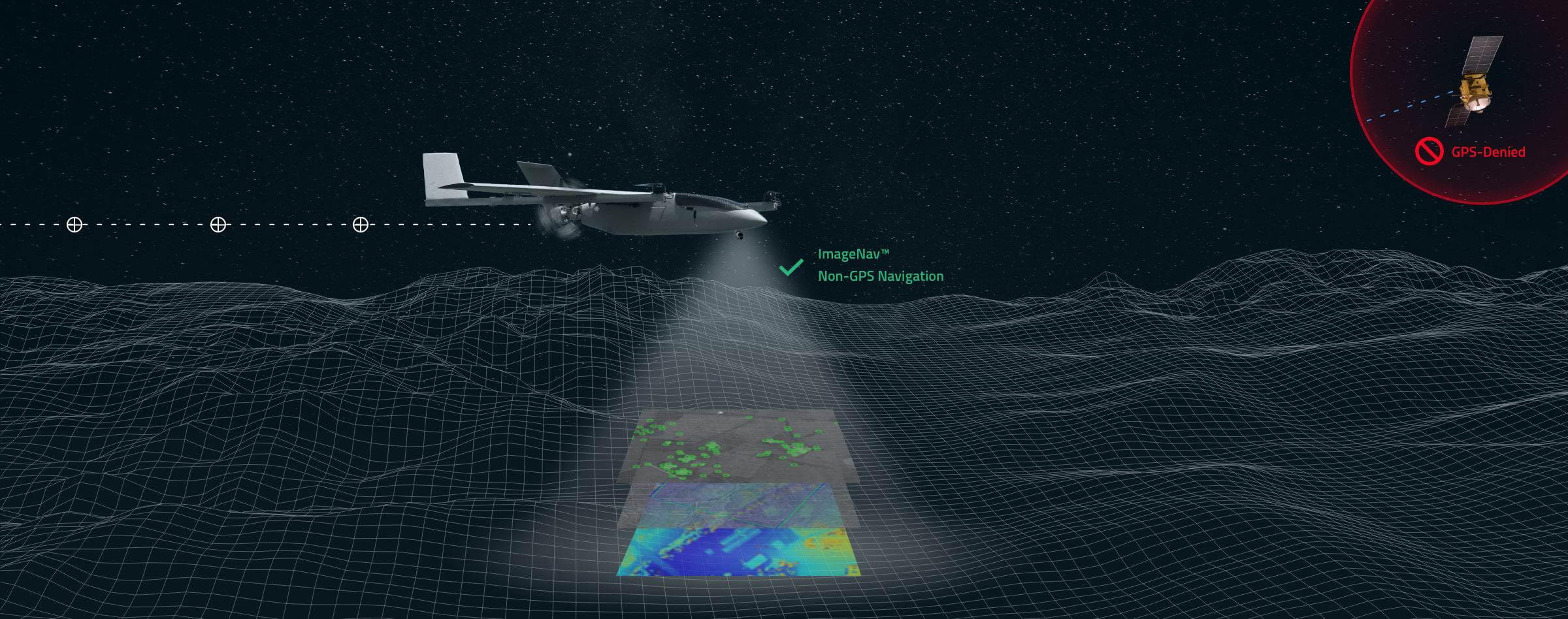
It is well-established that GPS signals are susceptible to intentional jamming and unintentional interference, as well as spoofing attacks where false signals are transmitted to mislead the receiver about its location.[7, 17, 53, 54] Furthermore, in environments with tall buildings or dense foliage, GPS signals can be significantly weakened or blocked, leading to reduced accuracy or complete loss of signal.[52, 54]
In the described multi-sensor system, RTK GPS can serve as the primary source of high-precision absolute position information whenever GPS signals are strong and a suitable reference station is available.[51, 52] Conversely, in scenarios where GPS signals are degraded or jammed, the Doppler GPS receiver can provide crucial velocity estimates. This velocity information can be used to extrapolate the device's position based on its last known location and the time elapsed, particularly when combined with the high-frequency motion data from the IMU. This allows for a degree of continued navigation capability, albeit potentially with reduced positional accuracy, even when standard GPS positioning is unreliable.[51] The integration of both RTK and Doppler GPS capabilities allows the system to leverage the high accuracy of RTK when possible and maintain some level of navigational awareness in challenging GPS-denied environments.
7. Fusing Absolute and Relative Positioning Data
A critical aspect of achieving robust and accurate localization is the effective fusion of absolute position information, derived from sources like celestial navigation or GPS, with relative motion estimates obtained from visual odometry and IMU data.[1, 42, 43, 44, 45, 46, 55, 56] Relative navigation techniques, while providing high-frequency updates on the device's motion, are prone to accumulating errors over time, leading to drift in the estimated position and orientation. Absolute positioning methods, on the other hand, provide periodic corrections to these accumulated errors by referencing a global frame of reference.[1, 43, 56]
When GPS signals are available and of sufficient quality, the absolute position fixes from the RTK GPS receiver can be used to periodically correct the drift inherent in the position and orientation estimates derived from visual and inertial odometry.[1, 56] Similarly, when GPS is unavailable or unreliable, absolute position information obtained through celestial navigation using the upward-facing star tracker can serve the same purpose, providing an independent global reference to bound the errors in the relative navigation estimates.[43]
Conversely, the high-frequency relative motion estimates from visual odometry (using the downward and directional cameras and optical flow sensors) and inertial odometry (from the IMU) can be used to provide a continuous and smooth navigation solution, particularly during periods when absolute position updates from GPS or celestial navigation are temporarily unavailable or unreliable due to signal blockage, adverse weather conditions, or other factors.[43] The relative measurements effectively bridge the gaps between absolute fixes, providing a continuous trajectory of the device's movement.
Various sensor fusion architectures can be employed to combine absolute and relative positioning data. These include loosely coupled approaches, where the outputs of the individual navigation systems are fused, and tightly coupled approaches, where the raw sensor data from different modalities are combined at an earlier stage in the processing pipeline.[42, 43, 44, 45, 46, 55, 56] The choice of fusion architecture depends on the specific requirements of the application, the characteristics of the sensors involved, and the computational resources available.
8. Map-Aided Localization using Earth Heightmap and Satellite Imagery
The onboard Earth's heightmap, often in the form of a Digital Elevation Model (DEM), provides valuable prior information about the terrain. This data can be utilized to aid in localization in several ways.[57, 58] For instance, the altitude estimated by the navigation system (derived from the fusion of various sensor data) can be compared with the altitude information from the heightmap at the estimated horizontal position. Significant discrepancies could indicate an error in the position estimate, allowing for corrections or increased uncertainty in the solution.[57, 58] Furthermore, the heightmap can potentially be used to predict the expected terrain profile beneath the device along its trajectory. This predicted profile can then be compared with real-time measurements from the Lidar or the downward-facing camera to refine the horizontal position estimate through terrain matching techniques.[58]
The onboard satellite imagery provides a global visual reference of the Earth's surface. Images captured by the downward-facing camera can be processed to extract key features. These features can then be matched with corresponding georeferenced features present in the onboard satellite imagery.[58, 59, 60] By establishing correspondences between the real-time camera imagery and the satellite imagery, the device's position relative to the global satellite image map can be estimated.[58, 60] This technique faces challenges such as variations in lighting conditions between the satellite and onboard camera images, seasonal changes affecting the appearance of the ground, and differences in the viewing angles.[58] Robust image matching algorithms and techniques for handling these variations are essential for successful map-aided localization using satellite imagery.
The localization information obtained through map matching (using both the heightmap and satellite imagery) can be further integrated with the data from other sensors in the system, such as GPS, celestial navigation, and inertial sensors.[61] This fusion can lead to a more accurate and reliable overall position estimate. For example, in urban environments where GPS signals might be weak or multipath effects are prevalent, matching features from the downward-facing camera with satellite imagery could provide a more accurate horizontal position than GPS alone.[61] Similarly, the heightmap can provide constraints on the vertical position, especially in scenarios where GPS altitude is unreliable. The integration of map data provides a powerful additional layer of information that can significantly enhance the performance and robustness of the navigation system, particularly in complex and challenging environments.
9. Sensor Fusion Algorithms for Optimal Latitude and Longitude Estimation
To effectively combine the data from the diverse array of sensors in the described configuration, sophisticated sensor fusion algorithms are required to produce an optimal estimate of the device's latitude and longitude. Kalman filters, including the Extended Kalman Filter (EKF) and the Unscented Kalman Filter (UKF), are widely used algorithms for this purpose.[38, 43, 44, 46, 56] These filters operate on the principle of predicting the future state of the system based on a dynamic model and then correcting this prediction using the measurements obtained from the sensors.[44, 46] The effectiveness of Kalman filters relies on having accurate models of the sensor noise characteristics and the dynamics of the system being estimated.[44, 46, 56]
Particle filters, also known as Sequential Monte Carlo methods, offer an alternative approach to sensor fusion, particularly suitable for systems that exhibit non-linear behavior or have non-Gaussian noise distributions.[44, 45] Unlike Kalman filters, which maintain a Gaussian probability distribution over the state, particle filters represent the system's state using a set of weighted samples or "particles." These particles are propagated through a motion model, and their weights are updated based on the likelihood of the sensor measurements given the state represented by each particle. Particle filters can handle more complex scenarios but may be more computationally demanding than Kalman filters.[45]
Beyond Kalman and particle filters, other sensor fusion techniques include complementary filters, which typically combine the outputs of two sensors with complementary frequency characteristics, Bayesian networks, which represent probabilistic relationships between variables, and increasingly, deep learning-based approaches that learn to fuse sensor data from large amounts of training data.[39, 45, 61] The choice of the most appropriate sensor fusion algorithm depends on a variety of factors, including the desired accuracy, the computational resources available on the Jetson Nano, the robustness required against sensor failures or noise, and the complexity of implementing and tuning the algorithm.[30, 31, 32, 33]
When considering implementation on the Jetson Nano, it is advantageous to leverage existing sensor fusion libraries and frameworks. The Robot Operating System (ROS) provides a comprehensive suite of tools and libraries for sensor integration and fusion.[41] OpenCV, primarily known for computer vision tasks, also includes some functionalities that can be used in sensor fusion applications.[30] Additionally, specialized sensor fusion toolboxes might be available depending on the chosen algorithm. Given the computational constraints of an embedded platform like the Jetson Nano, it is crucial to carefully consider the resource requirements of the selected fusion algorithm and to optimize its implementation for real-time performance.
10. Conclusion and Future Directions
In summary, the described multi-sensor configuration, when coupled with appropriate processing and fusion algorithms, holds significant potential for accurately determining latitude and longitude, even in GPS-denied environments. The system leverages the absolute positioning capabilities of celestial navigation (via the upward-facing star tracker) and GPS (including RTK for high accuracy and Doppler for velocity in jammed conditions), the relative motion estimation from visual odometry (using downward and directional cameras and optical flow) and inertial odometry (from the IMU), the environmental awareness provided by Lidar and ultrasonic sensors for local mapping and pose estimation, and the absolute heading reference from the magnetometer aided by an Earth's magnetic force database. The onboard Earth's heightmap and satellite imagery further enhance localization through map-aided techniques.
However, several challenges and limitations need to be considered. Accurate sensor calibration is paramount for reliable performance. Environmental conditions, such as adverse weather, poor lighting, or magnetic anomalies, can impact the accuracy of individual sensors. The computational resources available on the Jetson Nano might impose constraints on the complexity of the sensor fusion algorithms that can be implemented in real-time.
Future research and development could focus on exploring more advanced and computationally efficient sensor fusion algorithms that are particularly well-suited for heterogeneous sensor suites. Enhancements in daytime celestial navigation techniques, such as improved star identification algorithms and better mitigation of atmospheric effects, would further strengthen the system's resilience in GPS-denied scenarios. Advancements in map-aided localization, including more robust feature extraction and matching techniques that are invariant to changes in environmental conditions, would also be beneficial. Finally, optimizing the entire system for real-time performance on the Jetson Nano through efficient algorithm implementation and resource management will be crucial for practical applications.
In conclusion, the integration of this diverse array of sensors and the application of sophisticated sensor fusion techniques offer a promising pathway towards achieving accurate and robust localization for autonomous systems in various challenging environments, particularly where reliance on traditional GPS-based navigation is not feasible.